As of January 10, 2026, the Australian coastline is on high alert as Tropical Cyclone Koji (12U) intensifies in the Coral Sea. This system, which began as a tropical low (12U), has now developed into a significant meteorological event, threatening North Queensland with destructive winds and life-threatening floods.
Current Status of Tropical Cyclone Koji
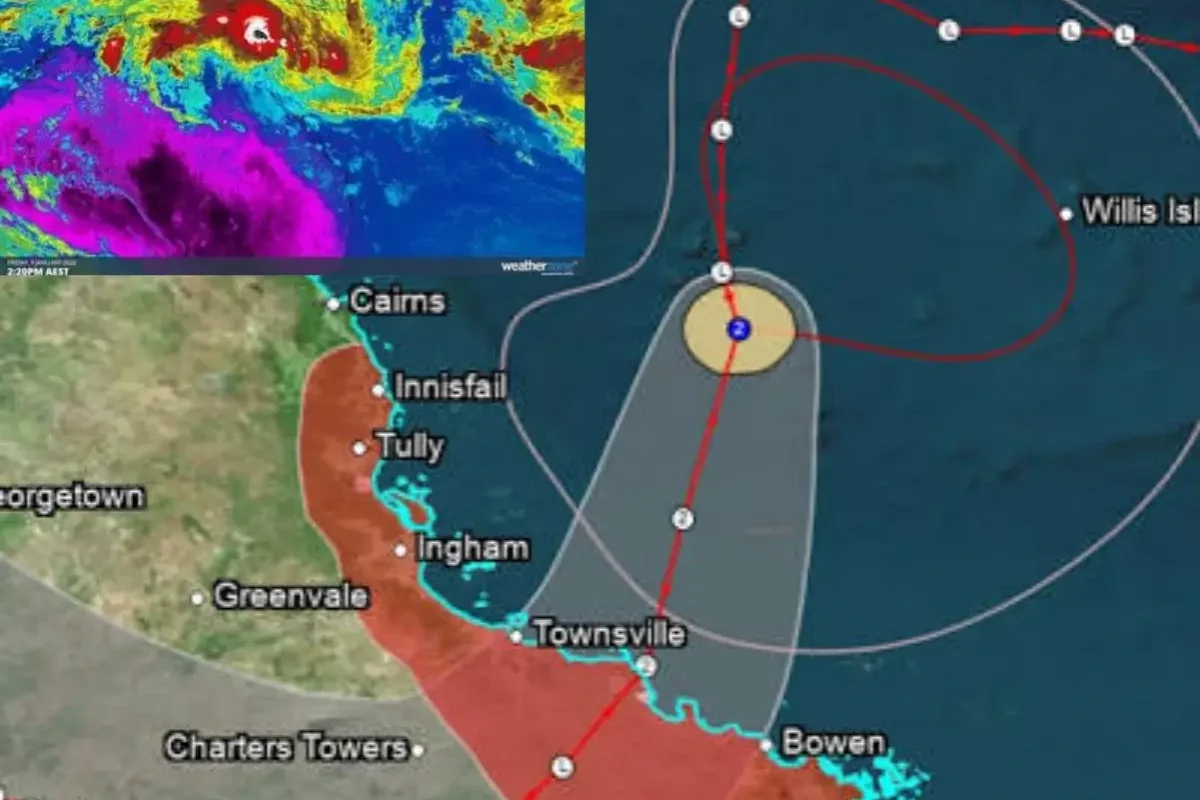
The Bureau of Meteorology (BOM) has officially classified TC Koji as a Category 2 system. As it moves south-southwest at approximately 11 km/h, the storm is gaining strength from the warm tropical waters.
- Sustained Winds: 95 km/h
- Peak Gusts: Up to 130 km/h
- Current Location: Off the northeast coast of Queensland.
Landfall Forecast and Tracking
Meteorologists predict that Tropical Cyclone Koji will make landfall early Sunday morning, January 11, 2026. The projected path shows the eye of the storm crossing the coast between Townsville and Bowen, likely near the town of Ayr
Residents in the "Warning Zone," which extends from Innisfail to Mackay, should prepare for a rapid deterioration in weather conditions within the next 12 to 24 hours
Potential Impacts: Winds, Rain, and Storm Surge
The 12U system is not just a wind event; it carries a massive amount of moisture, leading to several high-risk factors:
1. Destructive Winds
Gusts reaching 130 km/h are expected near the core. This is strong enough to cause structural damage to homes, bring down power lines, and uproot trees.
2. Life-Threatening Floods
Extreme rainfall is forecast for the regions between Tully and Airlie Beach. Totals could reach 250mm to 350mm in a single day, leading to dangerous flash flooding and river rises.
3. Storm Tide and Coastal Erosion
A storm tide is likely between Cardwell and Mackay. While it may not exceed the highest tide of the year, the combination of heavy swells and high winds will cause significant beach erosion.
Safety Preparations for Residents
With Townsville Airport already closed and local authorities issuing evacuation alerts for low-lying areas, here is what you need to do:
- Secure Your Property: Tie down outdoor furniture and clear gutters.
- Emergency Kit: Ensure you have a battery-powered radio, torches, 3 days of water, and non-perishable food.
- Stay Informed: Monitor the Bureau of Meteorology (BOM) and local ABC radio for the latest "Standard Emergency Warning Signal" (SEWS).
Conclusion
Tropical Cyclone Koji (12U) represents a serious threat to the Queensland coast in early 2026. As the system nears landfall, the priority for all residents must be safety. After crossing the coast, Koji is expected to weaken into a tropical low but will continue to bring heavy rain as it moves inland.
Sources:
- Bureau of Meteorology (BOM), Australia: Technical bulletins and tropical cyclone advice updates for the Queensland region (January 2026).
- Queensland Government Disaster Management: Public safety alerts and local disaster dashboard data for Townsville and the Whitsunday regions.
- Joint Typhoon Warning Center (JTWC): Track data and intensity analysis for System 12U/Tropical Cyclone Koji.
- Sky News Weather Australia: Meteorological reports on rainfall forecasts and coastal impact projections for Northern Queensland.